Патолошката потреба на нетуркиските источнобалкански народи по секоја цена да се идентификувaат како огурски (туркиски) Бугари
- Креатор на темата 121314
- Време на започнување


- Член од
- 3 септември 2010
- Мислења
- 6.787
- Поени од реакции
- 9.392

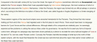
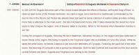
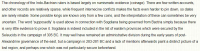
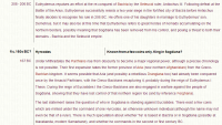
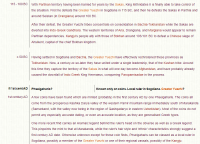
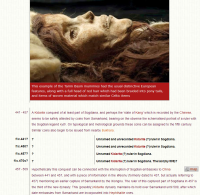
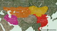
| Map of Central Asia & Eastern Mediterranean 334-323 BC |
| Alexander's campaigns which led him to the furthest reaches of Central Asia started off in Greece in 334 BC. His route can be followed here, starting from Pella, and using a different colour for each year of his travels, progressing through red, orange-red, mid-orange, light orange, yellow, lime, light green, cyan, and light blue, with the route ending at Susa in 324 BC. Following Alexander's early death his empire broke up into several Hellenic sections which maintained Greek cultural influence across a great span of the ancient world for several centuries. Alexander's immediate successors held no real power, being mere figureheads for the generals who really held control of Alexander's empire. |
Map of Central Asia & Eastern Mediterranean 334-323 BC
A map showing the route of Alexander the Great's journey of conquest through the Near East, Egypt, Persia, and Eastern Iran between 334-323 BC

- Член од
- 3 септември 2010
- Мислења
- 6.787
- Поени од реакции
- 9.392


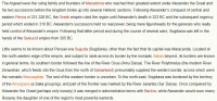
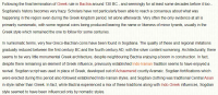
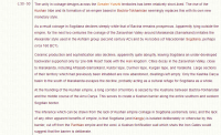
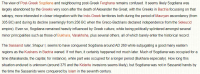
| Map of Central Asia & India (with Bactria) c.200 BC |
| The kingdom of Bactria (shown in white) was at the height of its power around 200-180 BC, with fresh conquests being made in the south-east, encroaching into India just as the Mauryan empire was on the verge of collapse, while around the northern and eastern borders dwelt various tribes which would eventually contribute to the downfall of the Greeks - the Sakas and Tocharians. |

- Член од
- 3 септември 2010
- Мислења
- 6.787
- Поени од реакции
- 9.392


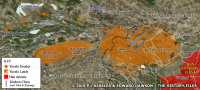
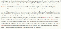
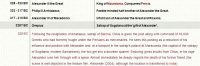
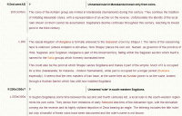
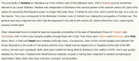
| Map of Yuezhi lands & exodus c.203-165 BC |
| The Greater Yuezhi were defeated and forced out of the Gansu region by the Xiongnu following a long struggle for dominance of the pasturelands to the north-west of the Han Chinese kingdom, and their migratory route into Central Asia is pretty easy to deduct from the fact that they chose to try and settle in the Ili river valley below Lake Balkhash. |
Map of Yuezhi Lands & Exodus c.203-165 BC
A map showing the Yuezhi lands and the route taken by them during their exodus, c.203-165 BC
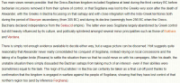
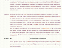
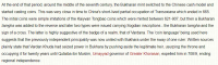
| Map of Central Asia and India c.50 BC |
| By the period between 100-50 BC the Greek kingdom of Bactria had fallen and the remaining Indo-Greek territories (shown in white) had been squeezed towards eastern Punjab. India was partially fragmented, and the once-tribal Sakas were coming to the end of a period of domination of a large swathe of territory in modern Afghanistan, Pakistan, and north-western India. The dates within their lands (shown in yellow) show their defeats of Greeks, gaining them those lands, but they were very soon to be overthrown in the north by the Kushans while still battling for survival against the Satvahanas of India. |
Map of Central Asia & India c.50 BC
A map of Central Asia and India around 50 BC
- Член од
- 3 септември 2010
- Мислења
- 6.787
- Поени од реакции
- 9.392


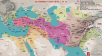
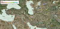
| Map of Central Asia AD 550-600 |
| As was often the case with Central Asian states which had been created by horse-borne warriors on the sweeping steppelands, the Göktürk khaganate swiftly incorporated a vast stretch of territory in its westwards expansion, whilst being hemmed in by the powerful Chinese dynasties to the south-east and Siberia's uninviting tundra to the north. |

| Map of Central Asia AD 600-700 |
| By the beginning of the seventh century AD, Göktürk power in southern Central Asia was waning, primarily because the khaganate itself had been subjugated by the Tang Chinese. The Sassanids had established a degree of control over the southernmost parts of this region, along with much of South Asia outside India itself, although details are largely obscure. In Sogdiana, divided from Tokharistan by the Iron Gate, and neighbouring Ferghana a patchwork of city states emerged in the late sixth century. This strengthened during the seventh century, with them initially seeming to be interconnected (although poor records may hide levels of discord). As the seventh century went on, though, they became more fractured, fighting one another for superiority and also fighting the sudden appearance of the Umayyad caliphate from the west. The caliphate itself, while trying piecemeal at first to conquer or subjugate, came into conflict with Tang China, which was enjoying one of the country's brief periods of external expansion. The various Chinese protectorates were establish to provide a protective buffer, with that of Anxi perhaps being the biggest and longest-established. The protectorate of Meng-Ch'ih ate into former Göktürk territory, while the Türgish Turks formed the eventual core remnants of western Göktürk power. |
Map of Central Asia AD 600-700
A map of Central Asia between about AD 600-700
Kingdoms of Central Asia - Sogdiana / Samarkand
Coverage of the various historical cultures, rulers, and states of the Far East
- Член од
- 3 септември 2010
- Мислења
- 6.787
- Поени од реакции
- 9.392
- Член од
- 3 септември 2010
- Мислења
- 6.787
- Поени од реакции
- 9.392
- Член од
- 3 септември 2010
- Мислења
- 6.787
- Поени од реакции
- 9.392
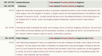
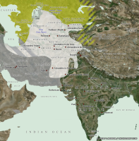
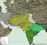
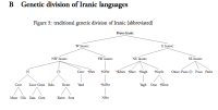
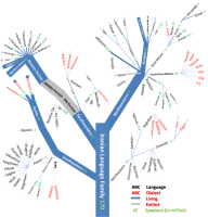
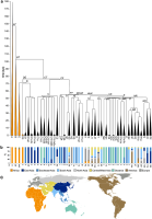
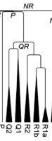
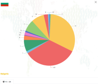
Види на 29, 30 и 31 страница од нишкава.Временската оска е во илјадници години?
Интересно е визуелизирано за лесно разбирање... Ако воопшто разбирам: Која е поврзаноста на R1a/b сo Q1/2 (Америките)??
Прегледај го приврзокот 423291
- Член од
- 3 септември 2010
- Мислења
- 6.787
- Поени од реакции
- 9.392
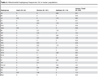
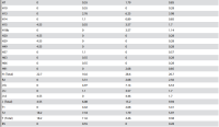
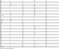

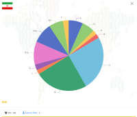
Complete Mitochondrial DNA Diversity in Iranians
Due to its pivotal geographical location and proximity to transcontinental migratory routes, Iran has played a key role in subsequent migrations, both prehistoric and historic, between Africa, Asia and Europe. To shed light on the genetic structure of ...
 www.ncbi.nlm.nih.gov
- Член од
- 3 септември 2010
- Мислења
- 6.787
- Поени од реакции
- 9.392


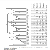
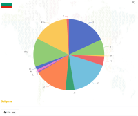
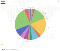
Y-Chromosome Diversity in Modern Bulgarians: New Clues about Their Ancestry
To better define the structure and origin of the Bulgarian paternal gene pool, we have examined the Y-chromosome variation in 808 Bulgarian males. The analysis was performed by high-resolution genotyping of biallelic markers and by analyzing the STR variation ...
www.ncbi.nlm.nih.gov
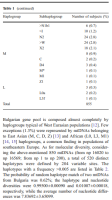

Bulgarians vs the other European populations: a mitochondrial DNA perspective - PubMed
To define the matrilineal relationships between Bulgarians and other European populations, we have evaluated the mitochondrial DNA (mtDNA) variation in a sample of 855 Bulgarian subjects from the mtDNA perspective. The molecular survey was performed by sequencing ∼750 bp of the control region...
 pubmed.ncbi.nlm.nih.gov
Последно уредено:
Vanlok
deus ex machina
- Член од
- 30 мај 2009
- Мислења
- 26.854
- Поени од реакции
- 35.834
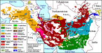
Во врска со ресурсов: Фасинантно, но мапата за Македонија им е заснована на премалку семплови.