- Член од
- 3 септември 2010
- Мислења
- 6.787
- Поени од реакции
- 9.392
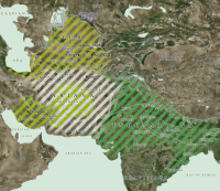
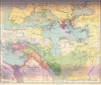
| Map of Central Asia & India c.700 BC |
| Following the climate-change-induced collapse of indigenous civilisations and cultures in Iran and Central Asia (not to mention Mesopotamia and Egypt) between about 2200-1700 BC, Indo-Iranian groups gradually migrated southwards from the Aral Sea and Syr Darya, with their offshoot, the Indo-Aryans, entering India (shown by the green diagonal stripes). By the first millennium BC the Indo-Iranians had created a poorly-attested 'land of Tur' (roughly outlined by the yellow stripes) and a great region (still vaguely-attested) known as Ariana (white), while in Iran the Parsua were in the process of forming a kingdom which would eventually subsume both (lime green). Their main opponent in the east, the kingdom of Turan, appears to have been focussed around Bactria and Margiana, and perhaps extending to the Elborz Mountains of the southern Caspian coastline. In India the dominant kingdom was Magadha, with a series of border kingdoms formed along its eastern flank. |
